


 Shkruar nga Pamfleti
DANA, (Depression Aislada en Niveles Altos ) is a typical meteorological phenomenon of Spain and the Western Mediterranean. It occurs when a cold air mass aloft is isolated from the main flow, forming a closed vortex. This configuration generates a strong contrast with the warm, moist air present at low altitudes, causing strong thunderstorms and heavy rain. The reliefs then worsen the rainfall. In the Iberian Peninsula, especially in autumn, DANA can cause episodes of extreme rainfall.
Cold point
DANA, a scientific term, is commonly called "cold spot" in the vernacular. Specifically, in meteorology "cold spot" refers to a limited volume of cold air in the upper atmosphere, which is represented on a weather map as surrounded by closed isotherms. In the modern world, the term is used to refer to any high-impact rainfall event during autumn along the western Mediterranean.
The origin
The popular term "cold drop" originates from the almost literal translation of the term coined by the German school kaltlufttropfen, which means "cold air drop". In Spain, a distorted use of the cold drop concept began to spread, associating it with any type of heavy rain, whether it was caused by an isolated high-altitude depression, an Atlantic storm, or a local storm.
Its origin is closely related, as already mentioned, to the polar current, the jet stream or simply the polar jet. Well, cold spots can stay almost stationary for days or sometimes they can move westward in the opposite direction to the prevailing air flow (ie drag). In Spain it appears when a very cold polar air front slowly advances over Western Europe at high altitudes (normally 5-9 km). The collision with the warmer and more humid air of the Mediterranean Sea generates strong and damaging storms. The effects associated with this depression of the upper layers are particularly visible in coastal areas where the waters are concentrated at a higher temperature than normal, which causes the increase of moist and warm air, which produces very intense precipitation and long.
In recent years, several DANA incidents have occurred in Spain. This is a fact that can be related to climate change as the Mediterranean is warming up very quickly and the water usually has quite high temperatures in summer and the following months. Some studies suggest that today it rains more on days with heavy rainfall than in past decades. This would be consistent with increased precipitation water in the atmosphere caused by a warmer Mediterranean. Rainfall is less frequent but more intense.
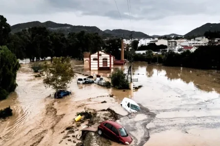
If we add to this temperature contrast the moisture and energy that a very hot Mediterranean offers after the summer months, the result is torrential rains, which often cause flooding in the affected areas. The data show that episodes of intense rain in the Mediterranean coastal areas caused by DANA are more and more frequent.
The precedents
According to the Spanish State Meteorological Agency, the cold wave that hit the Valencia area between October 29 and 30 is the worst of the 21st century, comparable only to two others: that of 1982, the so-called "Pantanada de Tous" (on October 20, a cold current caused the collapse of the Tous reservoir, Tous Pantanada and Júcar flooded the entire region of Riberas, causing serious damage to entire towns) and that of 1987 (on November 3 in Gandía and Oliva the rains of exceeded 50. /m² and destroyed the region of Safor In Oliva the Spanish record of rainfall in 24 hours was reached: 817 l/m² / Corriere Della Sera






Lini një Përgjigje