


 Shkruar nga Pamfleti
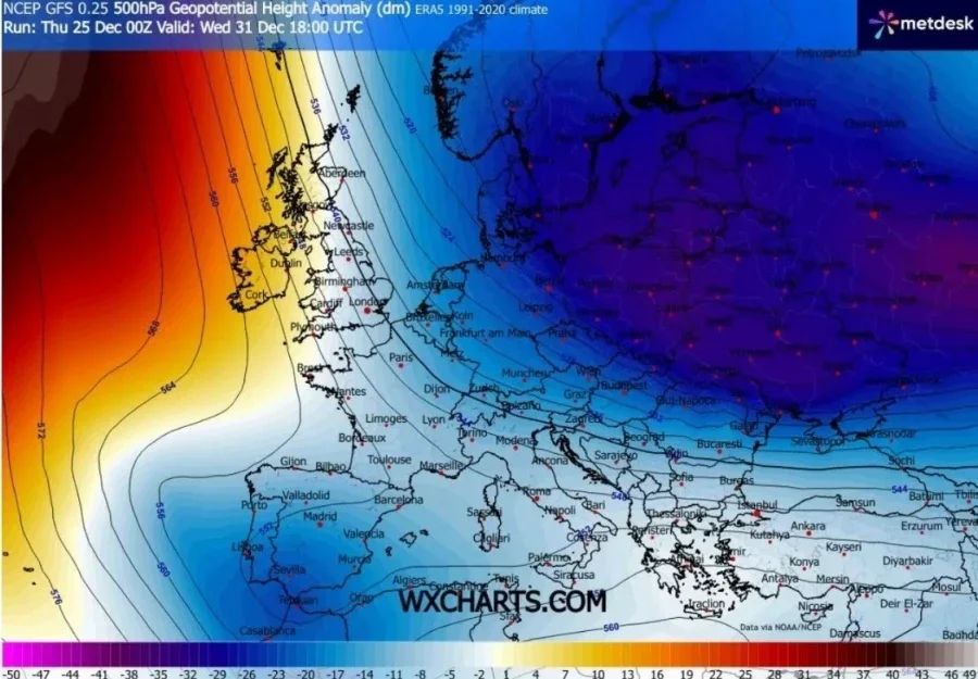
Meteorological forecasts indicate that by the end of 2025 and during the first days of January 2026, a massive influx of cold Arctic air could occur, which is expected to gradually affect a large part of Europe, including the Balkan region and Albania. This scenario, which comes after a period of relatively unstable weather in recent months, has been interpreted by meteorologists as a possible change in the temperature trend, with a significant deterioration in atmospheric conditions.
The main forecast models, including the ECMWF and GFS systems, are showing a trend towards a weakening of the westerly air flow and the formation of an atmospheric “blockage” away from the North Atlantic areas, which favors the entry of cold polar masses towards Central Europe and further south and southeast. This atmospheric physiology could create a “cold corridor” that promotes a drop in temperatures over large territories, including the Balkans.
However, experts warn that there is still no firm forecast for extreme weather, beyond this general trend. Detailed expectations for the amount of precipitation, the depth of snow or the moments when temperatures will drop significantly will only become clear closer to the event, as various factors influence the evolution of cold masses.
Among the main factors that will determine how and where it will be most affected are:
-Average temperatures in different layers of the atmosphere (such as at 1,500 meters and 5,500 meters altitude), which determine the nature of air masses and their movement.
-The freezing level in the atmosphere, which helps determine whether precipitation will fall as rain, snow, or freezing rain.
-The trajectory of the cold mass, whether it will pass over the Ionian or Aegean Seas and how it will affect the effects of snow in the areas surrounding the seas.
-The formation of pressure systems in the Central and Eastern Mediterranean, which could change the direction and strength of the cold system.
-The role of high pressure systems over the North Atlantic, which can divert the path of cold masses.
Meteorology specialists emphasize that the blue colors seen on forecast maps do not automatically mean that there will be snow at low altitudes or down to “sea level.” Even if cold masses reach Europe, for significant snowfall in Albania or the region, the cooperation of several of the aforementioned factors is required.
A small change in a pressure system or in the trajectory of cold masses can significantly change the distribution of precipitation and the areas where snow will fall. For this reason, authorities and citizens should carefully follow the daily forecast updates in the coming weeks, to assess whether we will have a pronounced cold wave with a wide impact, or just a cold spring with precipitation in mountainous areas.
First and foremost, the new forecasts will be useful for emergency services, transportation, energy, agriculture and local communities that need to prepare for different winter conditions, while the updated weather model will determine exactly how cold this beginning of 2026 will be for Albania and the Balkans.


Na.njoftoni.her.pas.here