


 Shkruar nga Pamfleti
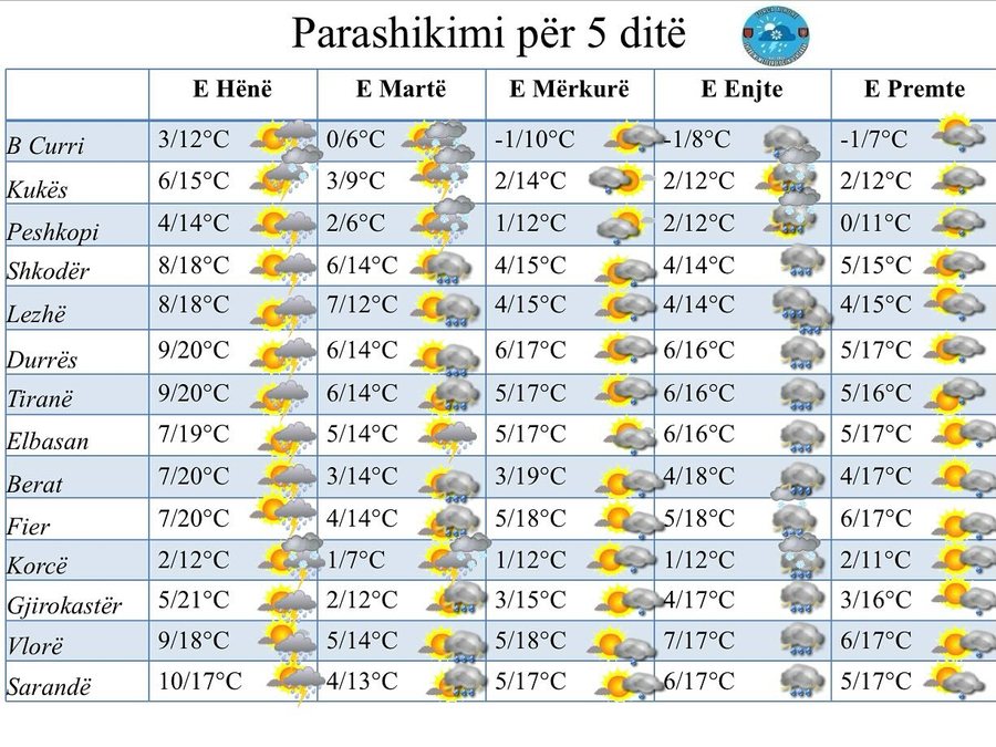
Our country during this week will be dominated by unstable weather conditions.
On Monday, Tuesday and Thursday, rain will be present mainly during the midday hours in the form of rapid downpours and short-term storms accompanied by lightning and hail.
Snowfall will be present in the Alps, in the northeast above 1400m and in the southeast above 900m with low to moderate intensity.
On Wednesday and Friday, the rain is expected to be occasional with low intensity, while occasional thunderstorms of a local character.
However, during these days there will be occasional intervals of clear skies and sunny hours.
Meanwhile, there will be fog presence in valley areas and partially low areas in the early hours of the morning and at the time of rain.
The occasional passage of some centers with high pressure values of Atlantic origin will make this week in our country dominated by unstable atmospheric conditions.
On Monday, Tuesday and Thursday, rain will be present mainly during the midday hours in the form of rapid downpours and short-term storms accompanied by lightning and hail.
Snowfall will be present in the Alps, in the northeast above 1400m and in the southeast above 900m with low to moderate intensity.
On Wednesday and Friday, the rain is expected to be occasional with low intensity, while occasional thunderstorms of a local character.
However, during these days there will be occasional intervals of clear skies and sunny hours.
The wind on Monday appears intense and problematic, with a direction from the south quadrant 2-9m/s, while on the coast and valley 11-17m/s, accompanied by waves of force 3-5
On the other days, the wind changes direction and decreases in intensity, becoming for most of the time in the southeast-northwest direction 1-6m/s, accompanied by waves of strength 1-2 fronts.
It is worth noting the presence of fog/haze in the valley areas and partly low areas in the early hours of the morning and at the time of rain.


Lini një Përgjigje